Called
"Geomatics" in Canada and much of Europe, land surveying is known as
the world's second-oldest profession. It dates back to ancient
Egypt and Babylonia. Surveying is
essentially the art and science of measuring and mapping land.
While the entire scope of our profession is vast, it all eventually
boils down to determining where people's land boundaries are located.
Without this service, railroads could not be built, skyscrapers could
not be erected, and individuals could not put up fences around their
yards, for fear of trespassing on someone else's land. Would you
like an interstate highway to be built in your backyard, one you've
paid for, maintained, and paid taxes on for years, without your
permission? Of course, how would you know it was in your
backyard without a surveyor to tell you where your property even was?
We also stake out boundaries of roads to be built, monitor skyscrapers
to make sure they are being erected vertically, and measure airports
so that the runways are perfectly aligned and smooth. So, if you
see a guy in the road looking through an instrument on a tripod, that
is a surveyor, now you know that he is doing more than taking
pictures.
What do
I do?
I am a
Professional Land Surveyor (PLS), licensed in the states of
Washington, Oregon, California, and Colorado. I am also a Certified Water
Rights Examiner (CWRE) in Oregon. I manage survey projects from
the office, performing calculations, contract management, and other
office tasks, such as writing legal descriptions, mapping, and prepare
finished products for our clients. I've been surveying
full-time since I was 15 years old, and I now work for
W&H Pacific, one of the
premier multi-disciplinary engineering and consulting firms in the
Western United States.
What is
a surveyor?
A surveyor is more than
one of those guys you see out in the road.
Surveying is a vital part of the design and construction process.
We perform boundary surveys to tell people where their property is,
map the topography of land for engineering design, establish
elevations of homesites for flood insurance, perform title surveys for
real estate transactions, certify that structures are built according
to design, lay out buildings, subdivisions and other construction
projects so the construction companies can relate the engineering
plans to the real world, and build control networks that all land
parcels can relate to in a given area. We also map slopes and
areas for pay volumes or quantities, map river bottoms for dredging,
lay out photo control for aerial photography and photogrammetry, write
legal descriptions that are used to describe pieces of property, map
and layout corriors for tunnels, roads, airports, pipelines, cellular
networks and railroads, and split up properties into new lots, such as
subdivisions. Below, I'll give you a brief overview of what the
guys you see in the road are really doing. The photos are a bit
out of date, but you'll get the idea.
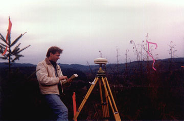
Global Positioning System (GPS)
GPS
is a tool we use for precise positioning of points. It
operates through satellites which send out signals to our receiver
(the thing on the tripod). The receiver then transmits those
signals to our data collector (the thing I'm holding), which
stores the data. After we get it into the office, we
download the data into the computer, and the computer software
resolves from the data the exact position of our point within a
few millimeters.
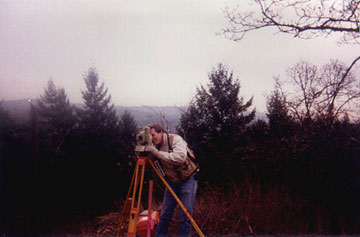
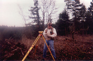
Traditional Total Station Surveying
The
primary function of the field surveyor is measuring, mapping, and
observing. Our most important tool for these purposes is our
total station (that's what I'm using in the top photo). It's
given this name because it incorporates a distance meter for
measuring distances and a theodolite for measuring angles into one
instrument.
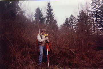
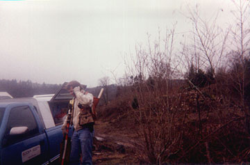
The
total station measures by sending a beam of infrared light toward
a prism, usually supported either by a tripod or a pole (like I'm
holding in the center photo). The light reflects off the
prism directly back to the total station. By measuring the
time it takes for the light to return, the total station
calculates the distance away that the prism is.
The
information that the total station measures (angles and distances)
is recorded in a data collector (that's what I'm holding in the
bottom photograph) for later downloading into a computer in the
office. The data collector also
doubles as a field computer, enabling us to calculate coordinate
geometry in the field and figure out the proper position in which
to put our stakes.
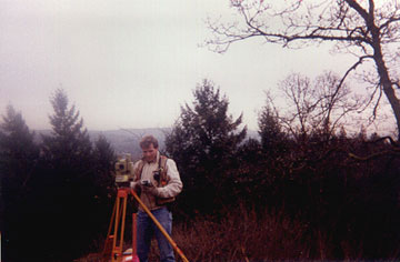
Leveling & 3-D Surveying
There are different ways we compute elevations of land. The
way I'm doing it in the picture is called differential leveling.
It's called this because you are calculating the difference in
elevation between two points on the ground. You basically
look at a ruler held on the ground and see how high above the
ground your level is set up. Then you look at the same ruler
on a different spot on the ground and see how high above that spot
your level is set up. This gives you the difference in
elevation between the points.
We
also derive elevations with our total station by using geometry
and measuring the angles and distances, and by Global Positioning
System by intersecting vectors from satellites in space, but this
is often the easiest way.
Project Management
Our
party chiefs are also in charge of coordinating the job with the
office, who coordinates it with the client. If the site is a
construction site, then they have to coordinate it with the
contractor. They receive instructions from the contractor or
our office as to what needs done, and develop a plan on how to
accomplish it in an appropriate time frame. You see our
truck in the picture in Columbia County, Oregon near Goble (don't
tell me you don't know where that is!)
HP33S CALCULATOR
THE BEST CALCULATOR
APPROVED FOR THE NCEES EXAMS!


 essentially the art and science of measuring and mapping land.
While the entire scope of our profession is vast, it all eventually
boils down to determining where people's land boundaries are located.
Without this service, railroads could not be built, skyscrapers could
not be erected, and individuals could not put up fences around their
yards, for fear of trespassing on someone else's land. Would you
like an interstate highway to be built in your backyard, one you've
paid for, maintained, and paid taxes on for years, without your
permission? Of course, how would you know it was in your
backyard without a surveyor to tell you where your property even was?
We also stake out boundaries of roads to be built, monitor skyscrapers
to make sure they are being erected vertically, and measure airports
so that the runways are perfectly aligned and smooth. So, if you
see a guy in the road looking through an instrument on a tripod, that
is a surveyor, now you know that he is doing more than taking
pictures.
essentially the art and science of measuring and mapping land.
While the entire scope of our profession is vast, it all eventually
boils down to determining where people's land boundaries are located.
Without this service, railroads could not be built, skyscrapers could
not be erected, and individuals could not put up fences around their
yards, for fear of trespassing on someone else's land. Would you
like an interstate highway to be built in your backyard, one you've
paid for, maintained, and paid taxes on for years, without your
permission? Of course, how would you know it was in your
backyard without a surveyor to tell you where your property even was?
We also stake out boundaries of roads to be built, monitor skyscrapers
to make sure they are being erected vertically, and measure airports
so that the runways are perfectly aligned and smooth. So, if you
see a guy in the road looking through an instrument on a tripod, that
is a surveyor, now you know that he is doing more than taking
pictures.