These pages
contain a trip report from our climb of Mt. Adams in June, 2001.
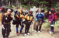
Our climbing party consisted of Sandra, my brother Gabe, our friends Pat,
Tom and Salima, and myself. The trip report consists of three pages,
so click on the arrow on the bottom of the page to read on. We've
also prepared a slide show of our photographs of the trip. Click
here to view the slide show!
At around
1:00pm on Saturday, June 22, we filled up our Ford Explorer and Tom's
Toyota 4-Runner for the final stretch up to Cold Creek Campground, where
the South Spur climbing route of Mt. Adams commences. Sandra sat
beside me, punching in coordinates for the waypoints I had selected from
our USGS Quad map prior to departure. "Uh oh, the batteries are
low on the GPS", Sandra exclaimed. I then realized that I had forgotten
to bring extra batteries on our trip! We headed over to the Trout
Lake, WA general store to pick up some extra batteries. We had no
idea at this time just how important that moment would become...
We signed
the climbing register, picked up our blue bags and inquired about the
weather forecast at the ranger station before heading up to the campground.
"Maybe a chance
of showers tomorrow, but it seems OK", they told us.
We headed
up Forest Road 8040500 toward the trailhead. We'd heard that the
road was rough, but so far it seemed OK. As we passed Morrison Creek
Campground, we found out that rough was quite an understatement!
Huge potholes, rocks, roots, and other obstacles awaited us on the narrow,
winding one-lane road up to the campground. We thrashed wildly up
the road, thanking the heavens for 4-wheel drive and lots of ground clearance,
and hoped against hope that no one would come the other way.
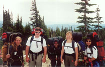
We finally
found the campground, and a parking space, packed up all our gear and
headed up to the trailhead. The trailhead is at around 5,600 feet
in elevation, which seems high until you realize that your destination
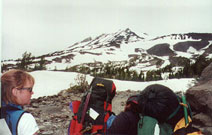
is 12,276 feet! At about 6,200 feet we hit snow, and by 7,000 feet
we were on the Crescent Glacier, well past the timber line. We steered
around the glacier to the left, and the route became steep. The
weather was beautiful, and the mountain offered us tremendous views of
Mt. Hood, Mt. Jefferson, and Mt. St. Helens, as well as the Indian Heaven
Wilderness and the surrounding valleys and peaks. Near the top of
the glacier, the girls spotted a rocky ridge with pre-built rock walls
to block the glacial winds. They grabbed the campsites and started
unpacking. As it was only 5:30pm at this point, I suggested we continue
on to the Lunch Counter, around 9,000 feet, an area known for its good
campsites and beautiful sunsets, but majority ruled and we decided to
stay at around 8,200 feet instead...
Click
the Arrow above to continue to page 2 of 3.
Click here to view the slide
show!
Visit
Top 50 Sports Sites to cast your vote for Johann & Sandra's Mountaineering!


 ages,
so click on the arrow on the bottom of the page to read on. We've
also prepared a slide show of our photographs of the trip. Click
ages,
so click on the arrow on the bottom of the page to read on. We've
also prepared a slide show of our photographs of the trip. Click
 n
is 12,276 feet! At about 6,200 feet we hit snow, and by 7,000 feet
we were on the Crescent Glacier, well past the timber line. We steered
around the glacier to the left, and the route became steep. The
weather was beautiful, and the mountain offered us tremendous views of
Mt. Hood, Mt. Jefferson, and Mt. St. Helens, as well as the Indian Heaven
Wilderness and the surrounding valleys and peaks. Near the top of
the glacier, the girls spotted a rocky ridge with pre-built rock walls
to block the glacial winds. They grabbed the campsites and started
unpacking. As it was only 5:30pm at this point, I suggested we continue
on to the Lunch Counter, around 9,000 feet, an area known for its good
campsites and beautiful sunsets, but majority ruled and we decided to
stay at around 8,200 feet instead...
n
is 12,276 feet! At about 6,200 feet we hit snow, and by 7,000 feet
we were on the Crescent Glacier, well past the timber line. We steered
around the glacier to the left, and the route became steep. The
weather was beautiful, and the mountain offered us tremendous views of
Mt. Hood, Mt. Jefferson, and Mt. St. Helens, as well as the Indian Heaven
Wilderness and the surrounding valleys and peaks. Near the top of
the glacier, the girls spotted a rocky ridge with pre-built rock walls
to block the glacial winds. They grabbed the campsites and started
unpacking. As it was only 5:30pm at this point, I suggested we continue
on to the Lunch Counter, around 9,000 feet, an area known for its good
campsites and beautiful sunsets, but majority ruled and we decided to
stay at around 8,200 feet instead...